

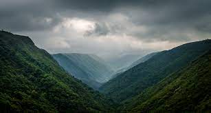
About khasi hills:
Khasi Hills, physiographic region, central Meghalaya state, northeastern India. The area consists mostly of hilly regions and includes the Shillong Plateau; it is drained by tributaries of the Brahmaputra and Surma rivers. The Cherrapunji scarp in the south has one of the highest average annual rainfalls in the world. Khasi Hills, and the entire Meghalaya state was administratively part of Assam before 1970. In older sources in particular, the alternative transcription Khasia Hills is seen.
The region came under the Khasi Hills district, which was divided into West Khasi Hills and East Khasi Hills districts on 28 October 1976. The highest peak is Lum Shyllong which is 1,968 metres high. It is situated a few kilometers south of Shillong town.The region is inhabited mainly by tribal Khasi dwellers, which are traditionally in various chieftainships, states known as the Khasi Hill States.
source from google
Activity:
Amazing view point , I love this place with natural beauty every whereBest Time to Visit: September, Monsoon, October, November, Autumn, December, January, Winter, February, March, Spring, April, May, Summer
Location: Shillong, Meghalaya, India
How to Reach There:
Airport: Shillong Airport
The nearest Airport Shillong Airport. We need to take an private vehicle the distance between Shillong Airport to Khasi Hills is 71.8 Kms
Railway Station: Mawkadiang Station
The nearest Railway Station is Mawkadiang Station. We need to take an private vehicle the distance between Mawkadiang Station to Khasi Hills is 58.2kms.
Bus Stand: Mawphlang Bus Stop
The nearest Bus Stand is Mawphlang Bus Stop. We need to take an private vehicle the distance between Mawphlang Bus Stop to Khasi Hills is 29Kms